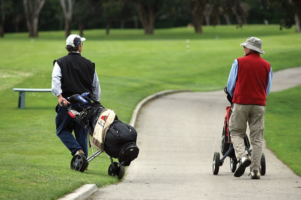


An ambitious regional plan to calm the flood-prone San Francisquito Creek could mean dramatic changes for golfers teeing up at the Palo Alto Municipal Golf Course.
The plan, which is being spearheaded by the San Francisquito Creek Joint Powers Authority (which includes officials from Palo Alto, East Palo Alto, Menlo Park, the Santa Clara Valley Water District and the San Mateo Flood Control District), involves building a levee that would encroach onto the golf course. This would mean modification to at least six and possibly as many as 12 holes at the 18-hole course, according to a new report from Rob de Geus, the city's golf manager.
The City Council will discuss the flood-control project and possible ways to reconfigure the golf course at its meeting tonight (Monday). The main question that the council will try to answer is: Should the city focus exclusively on flood control or should it take advantage of the creek-calming project to substantially upgrade the course.
Flood control around the creek emerged as a hot topic in the three cities in 1998, when the water overflowing from the creek caused significant damage to neighborhoods in Palo Alto, East Palo Alto and Menlo Park (Palo Alto officials estimate the damage at $28 million in the city alone). Since then, the creek authority and the U.S. Army Corps of Engineers have been performing separate studies to devise ways to improve flood protection.
Earlier this year, the creek authority hired the firm Forrest Richardson & Associates to come up with a reconfiguration design for the golf course that would accommodate the new levee. The firm came up with six options -- one focusing solely on readjusting the holes to fit the new levee and five others that would create more substantial changes to the course. The most conservative design would create five new greens and reconfigure at least six holes while the most ambitious one calls for 12 new greens and 12 reconfigured holes, according to a report Richardson will present tonight.
The cost of pursuing the six design options remains unknown, though the firm estimates that the cheapest alternative would cost about $3.6 million while one of the more substantial design proposals would cost about $4.1 million. Staff plans to present more detailed cost projections at a later meeting.
Though most of the cost would be picked up by the creek authority, Palo Alto would chip in more funds if it chooses to pursue one of the more complex alternatives, according to de Geus. The flood-control work, he wrote, "will be funded mostly or entirely by the SFCJPA depending on the Golf Course design chosen.
"That is, if the City chooses to take this opportunity to enhance the golf course beyond what is required to mitigate the flood control work the City will need to find additional funding sources to pay for the incremental difference in costs," de Geus wrote.
The council's debate over the future of the golf course is coming at a time when the facility is facing a gradual decline in usage. According to a 2008 economic study by the firm Economics Research Associates (ERA) the numbers played at the course dipped from about 90,000 in 2000 to 76,240 in 2007 -- a 16 percent decline. The report also found, however, that conditions at Bay Area golf courses have somewhat stabilized over the final two years of the studied period -- a trend that has given the consultants some reason for optimism.
"Over the next five-to-ten year period, the regional golf market is expected to continue to gradually improve as the 'baby boom' population ages in-place and limited expansion of the inventory of public golf courses occurs," the ERA report stated.
The council meeting will begin at 6 p.m. in the Council Chambers at City Hall, 250 Hamilton Ave.
Comments
Another Palo Alto neighborhood
on Dec 5, 2011 at 10:49 am
on Dec 5, 2011 at 10:49 am
The city council and CSD dept should jump on this opportunity to perform the full 12 hole upgrade to the golf course. The infrastructure of main line pipes irrigating the golf course are in need of replacement. This alone should reduce staff time and resources to keep the golf course up and running.
Duveneck/St. Francis
on Dec 5, 2011 at 12:04 pm
on Dec 5, 2011 at 12:04 pm
I thought that the flood in Palo Alto occurred because the Chaucer street bridge wouldn't let enough water thru. Does anyone know how building a levee on the golf course will help? In fact, this link Web Link shows that the golf course is on the bay side of the creek. Wouldn't a levee on the golf course just prevent creek water from getting into the golf course (and airport)?
Another Palo Alto neighborhood
on Dec 5, 2011 at 12:21 pm
on Dec 5, 2011 at 12:21 pm
The Palo Alto golf course tends to cater to non-Palo Altans--perhaps 70%-80% of the players do not live here. The land is worth about $500M, and is generating nothing of value for the City government, and the residents--in terms of profit.
So .. why not recognize that Palo Alto can no longer subsidize the leisure pursuits of people living in the area to the tune of $500M, by terminating the golf course operations, and looking for other uses of that land that will generate revenue for the City?
Sustainable government means living within your means -- and Palo Alto can no longer afford to give away its assets to non-residents in the future as it so liberally has in the past.
East Palo Alto
on Dec 5, 2011 at 1:38 pm
on Dec 5, 2011 at 1:38 pm
Giraffe, the flood in PA occurred due to many issues, incl the Chaucer St bridge. It flooded in many areas, incl well away from that creek.
You might want to check out the area east of 101 near the creek if you haven't already to see what could be affected by flooding over there - there are many businesses, the freeway, a school, multiple streets & of course, houses & schools on the EPA side of the creek.
Crescent Park
on Dec 5, 2011 at 1:44 pm
on Dec 5, 2011 at 1:44 pm
Yes - the bridges were, and still are a choking point. But the Federal Government will not let us just take out the Chaucer Bridge, or widen that area of the creek. Instead, there needs to be a way for the greater flow of water to make it all the way down to the bay.
Right now, if you open up Chaucer, the theory is that it will just cause greater flooding downstream --- so all choke points have to be fixed.
So essentially you have to start at the end point and work your way up the creek.
Community Center
on Dec 5, 2011 at 2:31 pm
on Dec 5, 2011 at 2:31 pm
Historicaly, didn't the creek used to go through what is now the golf course and dump into the tidal basin near where the yacht harbor used to be? Changing the course of the creek through engineering is what led to the flooding problems.
East Palo Alto
on Dec 5, 2011 at 2:38 pm
on Dec 5, 2011 at 2:38 pm
Don, if what you're saying about the previous track of the creek is correct, it'd be interesting to know historically if there were floods. Maybe I'll check into this.
Crescent Park Dad - thanks for your concise explanation about why the flood prevention project is happening this way - I know a lot of people haven't been clear on why the plans are being made this way.
East Palo Alto
on Dec 5, 2011 at 2:49 pm
on Dec 5, 2011 at 2:49 pm
Don, I found this link that supports what you said, but I don't know about the historical flood patterns that accompanied the original path of the creek: Web Link
Another Palo Alto neighborhood
on Dec 5, 2011 at 3:29 pm
on Dec 5, 2011 at 3:29 pm
There have been two major floods involving the San Francisquito Creek. 1955 and 1998. Supposedly there were some minor ones in the mid-1970s, but they didn't do much damage.
Registered user
Crescent Park
on Dec 5, 2011 at 5:20 pm
Registered user
on Dec 5, 2011 at 5:20 pm
The Chaucer bridge was built in 1948. Not only is the opening for the creek small and shaped so that as water rises there is dramatically decreased flow capacity, but the creek is also choked at the point of the bridge. That is-the creek is substantially wider both above and below the bridge. The result is with far, far less flow than it took pre-1948 there will be flooding from the site of the bridge. This is not a natural occurance but resulted from how the bridge was built.
Somehow as far a Palo Alto and other local government are concerned this bridge has become a legacy as sure as if it were a natural feature of the landscape.
Many homes below the bridge benefit from protection against flooding at the expense of homes above the bridge. The net effect is that at creek stages much lower than when previous flooding occured it now does flood at the site of the bridge. And water overflowing there then flows to a number of points in neighborhoods more than a mile away.
You could remove the entire golf course but the Chaucer bridge will still have the power to flood neighborhood because it is essentially a dam when enough water volume is achieved.
But now it is PC to leave it in place and address other complicated and very expensive projects downstream.
Crescent Park
on Dec 5, 2011 at 5:22 pm
on Dec 5, 2011 at 5:22 pm
The city DOES NOT subsidize the golf course. Every penny is paid by golfers and the profits go to the city for EVERY citizen's benefit.
And there are profits. In the last 7 years the golf course has earned $2 million in profit...
Stanford
on Dec 5, 2011 at 6:25 pm
on Dec 5, 2011 at 6:25 pm
Well, Mike, your pov is interesting because it's been much more common for flooding to have occurred below Chaucer St Bridge than above in recent years.
Barron Park
on Dec 5, 2011 at 7:32 pm
on Dec 5, 2011 at 7:32 pm
The creek was diverted in order to move the county line. Before that, the airport and golf course land was in San Mateo county.
Once the creek was diverted, water no longer flushed out the yacht harbor and it began to silt up.
The Oakland Museum has a beautiful set of historical creek maps.
Web Link
There is even talk now of moving the creek to the Faber-Laumeister Tract that Palo Alto owns, even more disaster.
The Beyond Searsville Dam folks have a lot of information concerning the historical politics of San Francisquito Creek.
qq
Another Palo Alto neighborhood
on Dec 5, 2011 at 9:14 pm
on Dec 5, 2011 at 9:14 pm
> The city DOES NOT subsidize the golf course.
The land that the golf course sits on belongs to the City, and is nominally worth about $500M. These has never been any attempt to charge the users of the golf course anything for the use of the land. Therefore, there is clearly been a $500M subsidy for this facility.
The golf course is occupying extremely prime land in Palo Alto, and generating virtually nothing in terms of profit, relative to the costs of the land, and the costs to operate.
The land should be repurposed, as soon as possible.
Crescent Park
on Dec 5, 2011 at 10:16 pm
on Dec 5, 2011 at 10:16 pm
"Well, Mike, your pov is interesting because it's been much more common for flooding to have occurred below Chaucer St Bridge than above in recent years"
Take a clue, pal. Water flows downhill.
Another Palo Alto neighborhood
on Dec 5, 2011 at 10:20 pm
on Dec 5, 2011 at 10:20 pm
It seems that shut it down wants to shut down every park and area of greenspace in Palo Alto. Following his logic, we might as well turn the whole city into a concrete jungle.
Fortunately, there are wiser points of view.
Crescent Park
on Dec 5, 2011 at 10:38 pm
on Dec 5, 2011 at 10:38 pm
Palo Alto needs healthy recreation for all ages. Remember that anyone from anyplace can play tennis on a Palo Alto city-owned tennis court even at night under expensive energy burning lights!! Not everyone sits glued to a computer or TV most waking hours nor is everyone studying 24/7. This golf course is a Palo Alto heritage and an asset. It returns a profit to the city. It charges non-residents higher fees. It is especially popular with children and teens, women, and seniors - adults of all ages. It is beautifully maintained, and it is a popular. Reconfigure if we must, but enhance and promote it. There's so much growing negativity in this town, and too many with no sense of Palo Alto's history, its heritage, and what made it what it is today.
Duveneck/St. Francis
on Dec 6, 2011 at 8:33 am
on Dec 6, 2011 at 8:33 am
Thanks for the comments about the Chaucer bridge. But, I didn't see any comments about why building a levee on the golf course would do anything except protect the golf course and airport. And wouldn't such a levee make flooding in E. P.A. more likely unless a matching levee were built there too? We could have levee wars like I've heard about on the Mississippi.
Registered user
a resident of Palo Alto
on Dec 6, 2011 at 9:21 am
Registered user
on Dec 6, 2011 at 9:21 am
Paul Losch from the Parks and Recreation Commission here.
I have had the good experience of attending meetings around the status of the Golf Course over the years, including some, not all, of the meetings around the current SF Creek re-configuration of the golf course and the land on which it sits.
My understanding of how to prevent future floods, such as the one we epxerienced in 1998, starts downstream, hence the work around where the creek ends at the SF Bay. Chaucer Bridge and other pressure points need to be addressed. And without getting it right at where the creek feeds to the Bay, work at other upstream places will not provide the desired benefits.
The creek was "re-engineered" decades ago in order to configure the golf course and the airport. That is simply fact.
I had a very interesting conversation recently with someone who is involved in industrial design. This person has no involvement with what goes on with the Creek, the golf course, the airport, or the Baylands. The point this person made was there is an incredible opportunity to re-design on a forward thinking basis on the way this part of Palo Alto can be put to its best use.
I personally support Council Member and former Mayor Burt's notion that we can have a great golf course and also support community needs for more playing fields.
But let's get back to design. Are we clear about our community's objectives for this part of land? I suggest that we are doing too much compartemptlizing, witness the compost vote in November, the on-going discussion about the airport, and now the land on which the golf course sits.
And let's get back to financing. Much of the money to fund this creek proje/flood control comes from the tithe that multiple local governments have contibuted to for years. It is difficult to question the source of funds, it is better to discuss how the funds will be used.
This community, like we find all around the state and country, is in a "hunkering down" mode. Asking and answering the bigger questions are in the back of the line. That may or may not be the best way to look at things at present.
From my point of view, we have an exciting opportunity to create a new vision for a large part of Palo Alto, and instead of siezing that opportunity, we are bickering.
Southgate
on Dec 6, 2011 at 9:39 am
on Dec 6, 2011 at 9:39 am
Building a levee is among the early logical steps to make Palo Alto and East Palo Alto neighborhoods less flood-prone, and to prepare for global warming.
Now is the time to consider the possibility of down-sizing the Palo Alto golf course to a 9-hole layout, developing new playing fields and earmarking land for one or more hotel properties around the golf course.
Golf recreation opportunities would still be provided, but so would more playing fields, escalating land lease revenue from very valuable property, visitor lodging and occupancy tax revenues so critical to Palo Alto (since 100% of the 12% occupancy tax goes to the City).
Duveneck/St. Francis
on Dec 6, 2011 at 7:54 pm
on Dec 6, 2011 at 7:54 pm
I think I found the answer to my question about how building a levee on the golf course would protect palo alto or e. palo alto in The Post today. The story there implied that there already IS a levee between the golf course and the creek. The plan is to MOVE this levee farther from the creek, ie, onto the golf course itself. This makes sense (I guess) because it would create more space along the creek to handle high volumes of water.
Registered user
Midtown
on Dec 7, 2011 at 1:45 pm
Registered user
on Dec 7, 2011 at 1:45 pm
The capacity of the Chaucer bridge could be increased by the installation of a jet pump to increase velocity at the bridge.
another community
on Jan 17, 2012 at 6:35 pm
on Jan 17, 2012 at 6:35 pm
Dear Shut it Down,
You are a perfect example of a man who knows the price of everything and the value of nothing.
Ohlone School
on Sep 2, 2012 at 9:04 am
on Sep 2, 2012 at 9:04 am
I live in the AE zone at Oregon and hwy 101. That means not only do we get the flood waters from overflowing creeks but we also get tidal floods. In 1998, many of my neighbors had to be evacuated by boat due to pooling flood waters. The 1955 and 1998 floods were primarily caused by the conjunction of rainwater, high tides, and the filling in of the marsh. The Joint authority has tried to address the blockage of the Chaucer street bridge and other bridges by improving the maintenance and cleaning of the creek (a major cause of blockage in '98) but to address tidal flooding we need to increase the area where water can pool. The purpose of the new or improved levee is to keep flood waters on the golf course and away from buildings.