

An eleventh-hour request from Palo Alto and Stanford University for a grant that would greatly accelerate the city's ambitious bike plan and create an expansive trail network around the Stanford Dish glided past the City Council Tuesday night and now heads to the Santa Clara County Board of Supervisors for approval.
The proposal, which the city and the university scrambled to put together over the past month, aims to tap into a $10.4 million pool that the county received from Stanford after San Mateo County decided not to use the funds to build a new trail at Alpine Road. The trail was one of two proposed as a mitigation for Stanford's "general use permit," which allowed the university to construct up to 5 million square feet of new development on campus. When San Mateo County declined to use the Stanford funds for the new trail, the money reverted to Santa Clara County, which now must use the money to enhance recreation opportunities for users of the Stanford campus.
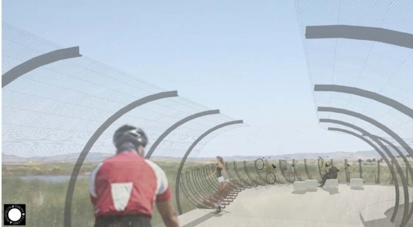
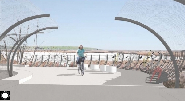
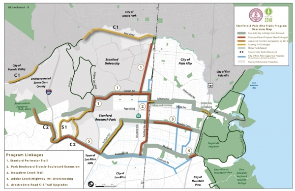
As Palo Alto Online reported Friday, the grant application that the two sides plan to submit requests funds for five projects -- $4 million for the proposed bike bridge at Adobe Creek; $4.5 million for new trails between El Camino Real and the Stanford Dish and along Junipero Serra; $200,000 to create the city's second "bike boulevard" at Park Boulevard; $1.5 million for a new bike-and-pedestrian trail along Matadero Creek, which would link Bryant Street and Greer Road; and $200,000 to enhance a trail along Arastradero Road, between Foothill Expressway and Purissima Road in Los Altos Hills.
View trail map (PDF)
The proposal was quickly put together by city staff and Stanford officials after initial disagreements about how the funds should be spent. City planners acknowledged Tuesday that they have much work to do when it comes to public outreach. But given the tight deadline -- the application is due Thursday -- they urged the council to support the ambitious proposal. Two of the projects in the proposal -- the bike bridge at Adobe Creek and the "bike boulevard" on Park -- are key components of the city's recently adopted Bike and Pedestrian Transportation Plan, a document that aims to transform Palo Alto into one of the nation's premier biking destination.
"We think this is a great opportunity for the city to hopefully kick-start our newly adopted Bike and Pedestrian Transportation Plan and to really significantly fund two of our major priorities," Planning Director Curtis Williams said Tuesday.
The council agreed and voted 6-0, with Councilman Sid Espinosa absent and Mayor Yiaway Yeh and Councilman Larry Klein recusing themselves, to support the application.
"I think that this is a strong grant application," Councilwoman Nancy Shepherd said. "I think it really is a great opportunity for Palo Alto to solidify our determination to get our bicycle paths built."
Her colleagues shared her sentiments. Vice Mayor Greg Scharff called the projects in the proposal "fantastic" and said he's very pleased that Stanford and Palo Alto were able to form a partnership. Councilwoman Gail Price agreed.
"I think, at the end of the day, a strong partnership among all the parties is very, very important and I think that we can each, in our own way, achieve outcomes that we jointly will be able to enjoy," Price said.
The joint proposal also earned plaudits from another important stakeholder group -- Stanford campus residents. Allyn Taylor, vice president of the Stanford Campus Residential Leaseholders, said her group (which is elected to represent the campus community) fully backs the joint application from the city and the university. The homeowners, she said, "are thrilled to be working with Palo Alto" on the grant proposal.
"Stanford homeowners are very much in support of this program that's been outlined to you today," Taylor told the council.
The campus residents hadn't always seen eye to eye with the city on the recreation funds. When Santa Clara County Supervisor Liz Kniss proposed in May to use the Stanford funds to pay for Palo Alto's bike bridge and to spend another $3 million to extend the Dumbarton link to the Bay Trail, campus residents protested that the two projects are too distant from the campus. They asked the Board of Supervisors to delay its vote and to consider other projects, including the campus residents' proposal to extend trails around the Dish.
University officials concurred that the process was moving too fast also asked the county supervisors to set up a more deliberative process for evaluating various grant requests. The Board of Supervisors agreed and is now scheduled to hold a public hearing on the grant proposals on Oct. 9.
The county issued its request for proposals in August, said Jaime Rodriguez, Palo Alto's chief transportation official. This left the city and Stanford with less than a month to put together a grant application.
The new plan, which the city and Stanford must submit by Thursday, differs markedly from the one Kniss pitched in May. The new grant proposal includes a wider range of bike projects than the previous one. It also includes the network of trails by the Dish that Stanford campus residents have long lobbied for. It does not, however, ask for any funds for the 27-mile Dumbarton link in the San Francisco Bay Trail, between Redwood City and Alviso.
Williams said the city decided not to pursue the Dumbarton link because that project would lie in San Mateo County, well outside the city's jurisdiction.
"The application needs to come from the sponsoring agency, and we're not that for the Bay Trail," Williams said, "It's not a project that we would sponsor and build."
Even so, the Bay Trail project could compete with the ones proposed by Palo Alto and Stanford. Adina Levin, a member of the Silicon Valley Bicycle Coalition, said the Midpeninsula Open Space District plans to submit its own application for that plan. The project, she said, would add value to the Palo Alto sections of the Bay Trail by making it possible for people to get from the city to San Mateo and Alameda counties.
But council members agreed that the city would have a better shot at getting county funds with the proposal offered by staff and Stanford. Rodriguez noted that the Dumbarton trail is located too far from the other elements in the proposal. The ones included, on the other hand, all link together in one cohesive network. The argument proved convincing to the council.
"I think the most important thing is putting our best foot forward and making our application as strong as we can make it," Scharff said. "The most important thing is to secure the funds to make this a reality."
So far, the Dumbarton trail link and the bike bridge are the only two projects that have been evaluated by the county's legal staff and deemed acceptable under the criteria of the General Use Permit, Kniss told the Weekly. It remains to be seen, she said, whether all the projects in the joint Palo Alto and Stanford application will likewise qualify under the conditions of the general-use permit.
"When all applications are in, staff will take a look and decide whether or not they will qualify," Kniss said.
Related stories:
• Palo Alto and Stanford team up on new trail proposal
Comments
Another Palo Alto neighborhood
on Sep 5, 2012 at 8:24 am
on Sep 5, 2012 at 8:24 am
Can we have some clarification please.
Are bike trails, mtb trails for serious mountain bikers? If so, these are not suitable for hiking or for road bikes.
If these are bike dedicated bike paths, will they also be something that are suitable for pedestrians to use?
I think it is very important to clarify if these are something that are going to draw mountain bikers from all over the area, or if they are something that just makes recreational biking and hiking as well as commuting, easier.
Another Palo Alto neighborhood
on Sep 5, 2012 at 8:33 am
on Sep 5, 2012 at 8:33 am
Here is a video of a serious bike trail? I think we need to know if one of these trails are what is being considered near the Dish. Web Link
Midtown
on Sep 5, 2012 at 8:38 am
on Sep 5, 2012 at 8:38 am
I'm glad that this project is finally getting started after 12 years of stalling.
However, I am very disappointed with the convoluted route they picked to cross I-280. The distance along this route is twice as long as it has to be, which will discourage almost all pedestrians from using it.
To answer the previous question, I'm pretty sure the trails east of I-280 are all paved and standard multi-use width (12 foot or so). West of I-280, they will probably all be narrow dirt trails.
Downtown North
on Sep 5, 2012 at 7:09 pm
on Sep 5, 2012 at 7:09 pm
These will likely all be paved "MUPs" (muli-use paths) like the Stevens Creek Trail. Most experienced bicyclists hate these MUPs because they can only be used at very slow speed due to the iPodestrians and inattentive side-by-side walkers. Foothill College has a short but interesting path that has a paved bikeway with a crushed gravel ped path next to it to reduce the conflicts. I wish that approach were more common.
Registered user
digital editor of Palo Alto Online
on Sep 7, 2012 at 9:13 am
Registered user
on Sep 7, 2012 at 9:13 am
The following comment was moved from a duplicate thread:
Posted by decimal point?, a resident of the Midtown neighborhood, 12 hours ago:
The Dumbarton trail is NOT 27 miles long like this article claims. Did the author forget a decimal point or reverse the digits? 0.72 mile is far closer to the truth. This is a very short trail (a couple of blocks) between East Menlo Park and East Palo Alto.
another community
on Sep 7, 2012 at 4:20 pm
on Sep 7, 2012 at 4:20 pm
Lets see... A bicyclist calling legitimate legal trail users "iPodestrians and inattentive side-by-side walkers".
If that's not the pot calling the kettle black, then I don't know what is.
Midtown
on Sep 9, 2012 at 8:24 am
on Sep 9, 2012 at 8:24 am
I'll suggest one correction in trail designation.
The existing trail shown in the S-1 designated area(from Junipero Serra west +splitting at Deer Creek rd+"Matadero Trail Hiking Path(MTHP)")
The Deer Creek rd split funnels walkers (+dogs) onto a hard pack dirt trail that heads over to Arastradero rd at Purissima, this trail is labeled"Matadero Trail Hiking Path(MTHP)" on the following link-map.
Web Link
Bicyclists are directed to stay on Deer Creek rd, and eventually end up at the same spot x Purissima rd+Arastradero rd.
My suggestion is that the MTHP be opened to bicyclists, fat tire,skinny tire alike.
This is a beautiful stretch of trail, we pedalers enjoy the scenic route just as much as any other trail user.
Two last thoughts,
I, like many other bicyclists, have 0 interest in mixing w motor vehicles while exercising.
With the ample "hiker only" trails by the dish, the ability to walk unfettered by having to share is readily available close by.
Please re-designate the MTHP as true multi use,