
Running a marathon in Palo Alto is an exhausting and exhilarating trial, with wild rabbits, disinterested horses, manic squirrels and the occasional heron or coyote offering welcoming distractions from steep hills and concrete lanes.
After meandering through the trails of Foothills Park, running up the new Matadero Creek trail, dashing past the Dish and proceeding up the Stanford Avenue trail, along El Camino Real, across the Caltrain tracks and toward the flat, marshy trails of the Baylands, a runner can easily forget that the scenic, leafy city is, to the wider world, largely synonymous with smart phones and silicon chips.
The marathon is a scenic course, with a slight flaw. Much like Plato's cave or Turing's machine, it only exists in theory. Unlike Berkeley or Half Moon Bay, Palo Alto doesn't have a flagship distance race. The city may be in the midst of turning itself into a bicycling mecca -- an effort that continues to accelerate thanks to a new master plan, numerous county and regional grants, unanimous City Council support and a vocal bike lobby -- but it hasn't been nearly as active toward promoting projects to support those whose favorite vehicle is their own two feet.
Not to worry. Life is about to get more exciting for Palo Alto's trail warriors. The city's already giant menu of scenic running options is expected to grow in the coming years as the council moves ahead with its ambitious Bicycle + Pedestrian Transportation Plan. Simultaneously, the city and Stanford University are moving ahead with a joint effort to build a network of perimeter trails around the Stanford Dish and along El Camino Real.
The Bicycle + Pedestrian Master Plan has ambitions well beyond narrow green lanes, "sharrow" markers and "bike boulevards" where stop signs are largely limited to cross streets. Though bikes are the main focus, the projects will have the barely intended consequence of creating scenic new running routes. Some of its objectives -- including creating a network of paths to "promote healthy active living" and maintaining "complete streets" accessible to all modes apply equally well to both physical activities. And Stanford's trail proposal includes "multi-use trails" that are geared toward bikers, runners and walkers alike, according to the university's grant proposal.
With that in mind, here are a few local projects that should boost a runner's high in the coming years.
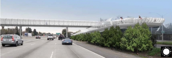
BAYLANDS BRIDGE: No project in Palo Alto has as much support or momentum as the proposed bike bridge between South Palo Alto and the Baylands. A cornerstone of the city's bike plan, the $10-million structure would span Highway 101 at Adobe Creek and replace an existing underpass that is typically closed for about six months a year. It has unanimous support from the council, the enthusiastic backing of the city's bike advocates and more than $8 million in county and regional grants.
This will, of course, be a boon to runners in the southern half of the city, who currently rely on the far less safe San Antonio Road overpass whenever the Adobe Creek underpass is closed. According to the Bicycle + Pedestrian plan, an estimated 100,000 bicyclists and pedestrians would use the bridge each year, a figure that is expected to rise "as adjacent bicycle connections improve and area land uses adapt." The new structure would encourage more runners to cross over to the marshy nature preserve and enjoy its 15 miles of trails.
Last June, just after the council voted to launch a contest for the design of the new bike bridge, Councilwoman Gail Price proclaimed that she's "never been happier with a vote in my entire life." Her colleagues were also stoked. Liz Kniss called Palo Alto an "elegant city" and said the bridge should reflect this. It would be nice, she said at the June discussion, if Palo Alto was known for more than its high-tech prowess. It should also be known as "the city with a beautiful pedestrian bridge." With the funds mostly in place and design work apace, residents who enjoy running past birds and marshland critters have plenty of reasons for optimism once the new gateway to the Baylands opens.
STANFORD PERIMETER TRAIL: Stanford University has been on a trail-building tear in recent years, with the latest milestone in 2012, when university officials unveiled a new 1.3-mile Matadero Creek trail along Page Mill Road, between Junipero Serra Boulevard and Arastradero Road. Part asphalt and part dirt, the multi-use trail near the Dish offers runners a brief but beautiful route, with horses and rabbits making the occasional cameo.
The trail was built as part of Stanford's agreement in 2000 with Santa Clara County over development rights on campus. Also, as part of that agreement, Stanford pledged to build a new trail along Alpine Road, a proposal that San Mateo County officials later rebuffed.
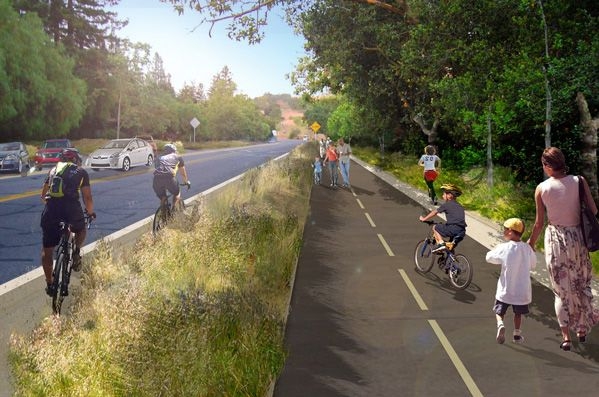
San Mateo County's loss may soon be Palo Alto's gain, with runners reaping major rewards. With the Alpine Road project rejected, Stanford contributed $10.4 million in funds to the county to be used for recreational projects benefiting the community. Two years ago, the county returned $4 million to Stanford in the form of a grant to build a "Stanford Perimeter Trail," a paved, multi-use pathway along Junipero Serra between Old Page Mill Road and Stanford Avenue; on Stanford between Junipero and El Camino Real; and on El Camino between Stanford and Quarry Road.
The perimeter will, among other things, fill in the missing piece in the existing Stanford Avenue pedestrian trail between El Camino and Junipero Serra, a trail that now stops abruptly at Raimundo Way but that will now be extended to the Dish. The project will also include a widened sidewalk on various segments of Stanford Avenue; a new 12-foot-wide trail segment connecting the Matadero Creek trail with the entrance to the Dish; and new buffers between cars and pedestrians all over the trail network. For runners both in Stanford and in Palo Alto, this is good news.
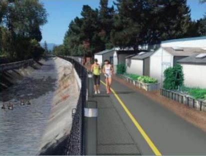
MATADERO CREEK: While Stanford's new Matadero Creek trail keeps a low profile on the periphery of Page Mill Road, Palo Alto's proposed trail of the same name would cut right through the middle of the city. For this reason, it has already attracted some concern and opposition from residents whose yards the new trail would run through. City planners and bicyclists, meanwhile, see the new trail as a much-needed panacea to Palo Alto's insufficient east-west connections.
The trail would follow the creek's existing levees and access roads and stretch between the Caltrain tracks and the entrance to the Baylands near U.S. Highway 101. On March 17, the council unanimously approved a contract for a feasibility study to consider "community-preferred alignments" for the Midtown trail and across-the-barrier connections at both ends of the trail.
The trail is included in the city's bike master plan and has already received $1.5 million in grant funding from Santa Clara County.
SIDEWALKS: Wider sidewalks mean more room to run, a welcome thought for runners who frequent California Avenue, live near El Camino Real or prefer roads to trails. Palo Alto last month broke ground on the long-planned renovation of the eclectic and centrally located business district, an effort that would transform the city's second downtown into a "complete street" that is as welcoming to bicyclists and pedestrians as it is to cars. The project includes more landscaping, new plazas, enhanced crosswalks and fewer driving lanes.
Other streets may follow suit. The council is scheduled to consider later this month a new "area concept plan" for the locality around California Avenue. One of its many recommendations is to make life safer for pedestrians and bicyclists on Park Boulevard, which has seen a recent growth in high-tech startups. The plan includes as one of its policies: "Enhance the pedestrian environment along Park Boulevard with such improvements as wider sidewalks, re-striped crosswalks, or additional pedestrian amenities."
In the longer term, Palo Alto is hoping to widen sidewalks on El Camino Real by adopting zoning rules requiring new developments on the car-heavy thoroughfare to accommodate sidewalk widths of at least 12 feet, with an average building setback at 15 to 18 feet. At recent public hearings, the proposal has been criticized by El Camino property owners concerned about new restrictions on redevelopment. The main beneficiaries, meanwhile, would be pedestrians, which includes runners. Even if El Camino never lives up to the "grand boulevard" vision of local and regional authorities, the King's Highway could become a useful conduit for runners heading toward Stanford Avenue, the university campus or the trail network near Page Mill Road.
Comments
Midtown
on Apr 18, 2014 at 9:08 am
on Apr 18, 2014 at 9:08 am
Palo Alto's pedestrian routes are so haphazard right now. We can't wait for a safe and direct east-west pedestrian route from the Palo Alto Baylands to the Arastradero Preserve. Seems to me that pedestrian access to all parts of town should be a fundamental part of public planning. Thanks to all the people who are working on this.
Another Palo Alto neighborhood
on Apr 18, 2014 at 9:36 am
on Apr 18, 2014 at 9:36 am
A solid, designated Bike/Ped trail that reaches from the bay to the western flanks of the city would be a great asset. Ask how the Steven's Creek trail has worked out for Mountain View over the past 20 years or so. Its become a sort of "Spine", if you will, for access into the other areas of town. Something similar would be great in PA, but not sure we're capable with so much opposition to every little thing.
Midtown
on Apr 18, 2014 at 10:11 am
on Apr 18, 2014 at 10:11 am
Technically, Palo Alto's western flanks reach all the way up to Skyline. I would be happy just to get a safe and direct pedestrian route along Page Mill Road past I-280. Those detours that range miles out of the way through Menlo Park or Los Altos are really unacceptable.
Evergreen Park
on Apr 18, 2014 at 11:12 am
on Apr 18, 2014 at 11:12 am
You can already walk from Arastradero preserve all the way to Waddell beach on trails and fire roads. I've done it. I would love to see the final segments connected up so that we can have the ultimate bay to ocean 60 mile trail.
Midtown
on Apr 18, 2014 at 3:53 pm
on Apr 18, 2014 at 3:53 pm
@Runner - we think it is really great that you can start a great run at Arastradero Preserve, but the problem is how do you safely get from the residential part of Palo Alto to the Arastradero Preserve without driving? I am not letting our kids walk along Page Mill Road, even with adult supervision, especially the I-280 interchange. From Foothill Expressway to Arastradero Road is only a couple of miles, but it feels like the Berlin Wall to our kids.
Los Altos Hills
on Apr 19, 2014 at 12:41 pm
on Apr 19, 2014 at 12:41 pm
I think it is pretty easy to get to Arastradero Preserve via the Dish Trail and using the cattle tunnel under 280 - sure you have to jump a fence or two - that is way we went 40 years ago. Not sure why people need a yellow brick road to do things.
Stanford
on Apr 20, 2014 at 12:25 pm
on Apr 20, 2014 at 12:25 pm
There are 3 critical problems in the Stanford to Arastradero area, and the current plans do not solve them.
1) The continued parking on one side of Stanford Avenue will perpetuate an extremely dangerous, noisy, and congested area that has proven enormously frustrating to the people who try to park there. For cyclists, the constant illegal U turns, people parked on the road waiting for a space to open, and the people backing into or out of spaces create a hazard that prevents any sane parent for allowing their kids to cycle there. The photograph at the top of this article nicely captures some of the ongoing problems, since it shows bikes on the same path as the pedestrians as well as on the street--though this side will be better than the other side where the parking cars will have a poor view of oncoming cyclists. The density of people, bikes, and cars shown is an idealists view and not at all a real depiction--on weekends the area is far more congested than this and collisions are certain. For residents of the area, the frequent car horns, car alarms (typically beginning by 6 on weekends), and occasional breaking glass have turned the peaceful area they chose for their homes into an unpleasant noisy place where it is hard to work at home. Recent burglaries in the area may have been made more likely because there is plenty of "cover" for parking for thieves. The obvious solution is to move the parking area completely away from the residential area--and providing enough of it. There should be an entrance to the Dish area from Old Page Mill, and a parking area similar to the one at Arastradero Preserve created near its north junction with Page Mill. The present plan, Coyote Road parking and all, will not relieve the congestion at Stanford. Our children cannot be safe in that area unless they bike through the pedestrians--and that's certainly not a good idea.
2) Another problem, getting past the Page Mill/280 intersection, is a serious one too since the useful tunnel mentioned by Alphonso (above) is not a legal route. The tunnel does not, in any case, have any access for cyclists so unless a route through the Dish area for cyclists is provided, something else is needed for them. Better demarcation of bike routes through the 280 intersection would at least be a help. Right now a cyclist has 50mph+ cars on both sides.
3) Even if a child was to survive biking under 280, they would then face Arastradero Road which has no bike path or lane in either direction and is the site of many close calls with cars and bikes. It should have bike lanes in both directions from Page Mill to Alpine Road.
It would sure be nice if the new plans actually solved these three critical problems.
Midtown
on Apr 20, 2014 at 5:06 pm
on Apr 20, 2014 at 5:06 pm
I remember Stanford promising to build a child-safe bicycle/pedestrian route from Stanford Ave to the Arastradero Preserve, in exchange for building permits from Palo Alto. That was more than 10 years ago and Stanford got everything they wanted and we families still have nothing. Shame on me for trusting Stanford. Shame on our city leaders for not keeping their foot on Stanford's throat until they kept their promise.
Registered user
Stanford
on Apr 20, 2014 at 9:14 pm
Registered user
on Apr 20, 2014 at 9:14 pm
This is a wonderful plan on Stanford's part. Kudos to the university for generously providing access to the trails on THEIR property. No doubt most of the surrounding community is grateful--as they should be.