
Both in terms of geography and significance, the proposed bike path along Matadero Creek was supposed to be the centerpiece of Palo Alto's bike-improvement boom.
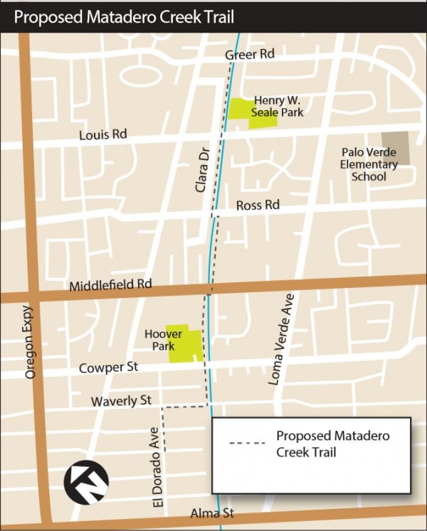
Conceived as part of the city's bike and pedestrian master plan, the new trail was supposed to stretch for about 1.3 miles along the creek's levees between Alma Street and Bayshore Road. The goal was to address a problem that unites cyclists in the north, south and central Palo Alto: the lack of quality east-west routes.
The Matadero Creek project got off to a solid start, winning a $1.5 million grant from Santa Clara County and earning widespread support from the prior City Council, which unanimously approved the bike plan in 2012. In addition to creating a new pathway, officials also hoped to build bike crossings at the Caltrain tracks and at U.S. Highway 101.
In promoting the project, the city's bike master plan notes that the 1.3-mile distance between the Caltrain undercrossing at California Avenue and the street-level East Meadow crossings represents the longest stretch of track barrier in Palo Alto. The lack of east-west connectivity in this area, the plan states, is "a major issue for the Cal-Ventura area, a mixed-use neighborhood with potential for new residential and mixed-use development near the Fry's Electronics site and along El Camino Real." The plan recommends that the city conduct a feasibility study to determine the specific alignment for the path.
Now, however, the project is taking an unexpected turn thanks to obstacles both physical and political in nature. Since the bike plan was adopted, dozens of Midtown residents have come out against the project, arguing that the creekside trail would pose a safety hazard and bring down property values in the area. A group of concerned Midtown residents (that, fittingly, called itself Concerned Midtown Residents) urged the council to go back to the drawing board and consider other options for improving east-west connections near the city's center. In addition, a preliminary analysis by the city indicated that the trail project would be more costly and complex than initially thought because of flood-protection measures that are being implemented by the Santa Clara Valley Water District, which has jurisdiction over the creek.
These complexities have prompted the city to pursue a new direction for the project, one that shifts the new east-west bike route away from the creek and to one of the streets in the Midtown area. Reflecting the change in thinking, the project that was formerly known as the Matadero Creek Trail is now referred to as the Midtown Connector.
Over the past two months, staff has discussed the change with the specially appointed Citizen Advisory Committee that was tasked with evaluating this project and with the city's Pedestrian and Bicycle Advisory Committee (PABAC), a panel that reviews all bike-related endeavors.
Sarah Syed, the city's senior transportation planner, highlighted the new challenges in her September report to the Citizen Advisory Committee. The effort by the water district to improve flood-control, she said, includes construction of access-closure structures, which are installed across the existing maintenance road annually, from October to April at Middlefield, Louis and Greer Roads, Syed wrote in her report. The structures are required for flood control during high water events, she wrote. The creek trail, she noted, "was not a priority for either agency during the planning process for the flood control project, when trail infrastructure might have been designed in harmony with the project."
Another point of concern is access ramps that would need to be installed along the creek for maintenance vehicles. The preliminary concepts for these ramps indicate that the trail would ramp steeply up and down at four locations along the creek, with the ramps splitting off at the low points and leading to the channel.
The 5 percent grade at these locations, she wrote, "are not comfortable for many people who walk and bicycle."
"Due to existing block lengths, trail users would experience few flat segments of trail," Syed wrote. "Other area trails that ramp up and down typically do so to provide benefits to users, such as grade separated crossings of intersections. Coupled with at-grade crossings of intersections, the ramp configuration required for maintenance access would likely discourage many potential trail users."
These constraints were enough to convince both advisory committees, each of which went along with staff's recommendation to halt the feasibility study and pursue other options.Robert Neff, who serves on both PABAC and the citizen committee, said the Midtown project faced significant opposition from the get-go among some members of the citizen group. Opponents cited privacy and security concerns, as well as inadequate safety at street crossings. There was an air, he said, that "these are really bad problems and we just shouldn't do this."
Yet it was the flood-control work and its impacts on the trail that posed the greater problem from the city's perspective, he said. It became quickly apparent that the project would be far more expensive than the projected $2 million price tag. Furthermore, it became clear that even if the trail were built, concerns about flooding would keep it from being a year-round facility. According to Syed's report, the water district stipulated that if the city were to pursue the trail on the levees, it would have to take "full responsibility to close trail to public and install access closure structure in advance of significant rain event and to remove them following a significant rain event." In addition, the city would be obligated to keep the trail closed during the rainy season, why typically stretches from October to April.
"There were all these changes that were made to the channel where the places you thought were accessible were not easily accessible year-round without leaving the city liable for flooding in the neighborhoods if they did it wrong," Neff said.
Both advisory boards went along with staff's suggestion to halt the feasibility study and to evaluate new alternatives. These include new bike amenities along Loma Verde Avenue, Colorado Avenue or East Meadow Drive.
One consequence of abandoning the Matadero Creek project is that the city may have to return the $1.5 million to Santa Clara County for reallocation to other projects. According to a new report from planning staff, the city would coordinate with the county to advance other local bikeway projects to compete for funding.
Comments
South of Midtown
on Nov 5, 2015 at 10:12 am
on Nov 5, 2015 at 10:12 am
Are we ever going to get a really safe east-west bike path through southern Palo Alto, or is Charleston Road the best the city can do?
South of Midtown
on Nov 5, 2015 at 10:35 am
on Nov 5, 2015 at 10:35 am
An important part of the Matadero bike path was a new bicycle bridge over the Caltrain tracks connecting Midtown to the California Ave train station and business district. Can we at least get the bridge if the rest of the bike path is canned? Safer bicycle access across the train tracks is the major bottleneck to bicycle commuting from Midtown. The existing tunnel on the north side of Oregon Expressway is really substandard.
Another Palo Alto neighborhood
on Nov 5, 2015 at 10:40 am
on Nov 5, 2015 at 10:40 am
We would not be directly affected by the Matadero Trail, but have friends who would, and I completely agree it is a bad idea. Residents who's homes abut the creek would suddenly find themselves with a significant loss of privacy and security.
The creek walls are elevated for flood prevention, so the flat ground along the creek is elevated quite a bit higher than the properties abutting it, which means bicyclists, joggers, and walkers would suddenly be walking along that path looking straight down into the backyards of these properties, even with the maximum height fences allowed on the home side (and increasing fence heights to 10-15 feet would close in these yards horribly). Opening up this access would also pose a security risk as anyone could easily hop over the fence into these backyards, day or night.
This, combined with the risks where the path meets roads, make this a very bad idea. How about designating California Avenue, with it's underpass, as a bike route, and at Bryant or Cowper have the route jog over to another east-west street with lower vehicle traffic, like Colorado or Loma Verde, then to Louis, then to wherever the freeway overpass will connect?
Greenmeadow
on Nov 5, 2015 at 10:43 am
on Nov 5, 2015 at 10:43 am
This project is not a lost "center piece" as the writer implies. We do need a midtown connector, but it doesn't HAVE to be in the creek bed. The city will now need to look at alternate routes in midtown. There's no question that an east-west connection in this part of town is critical--even WITH the Charleston-Arastradero Plan. South Palo Alto has far fewer east-west routes for bikes and pedestrians than the north with very long distances between them. That was made very clear by the city's Bicycle/Pedestrian Transportation planning process AND the rail corridor study.
Midtown alternatives will need to be identified. It's not an impossible task. This is how transportation planning processes go. You propose a possible option and then study feasibility. If the proposed solution can't work, you look at other options.
Let's keep level heads and stick to creative problem-solving. An east-west connector IS a VERY important element of the plan. I'm sorry this specific solution doesn't work, but I'm confident we can can identify one that will work if we roll up our sleeves and work together.
Thanks to Ms. Syed for pushing rapidly forward on feasibility. Now that we know what can't work, and we know we need alternatives. Let's get to work.
Midtown
on Nov 5, 2015 at 10:44 am
on Nov 5, 2015 at 10:44 am
This bike path should be canned. Many of the homes along Matadero Creek back onto the creek, why should they have their privacy interrupted with bicyclists? - Just say "no".
South of Midtown
on Nov 5, 2015 at 10:46 am
on Nov 5, 2015 at 10:46 am
California Ave may be a fine bike route for kids living on the north side of Oregon Expressway, but many parents won't let their kids bike across the expressway. Even the Bryant & Oregon intersection is sketchy for younger teens because of the narrow road width and cars turning across your path from multiple directions. The very long red light also discourages kids from using this route. A direct bike route from Midtown to the Caltrain station would be much much safer and more convenient.
Barron Park
on Nov 5, 2015 at 10:57 am
on Nov 5, 2015 at 10:57 am
I like the idea of relocating the bike path along California Avenue. Is that possible realistically? And to the Palo Alto Weekly reporter, this is a good article, putting some sunshine on a topic that few of us know about.
Palo Alto High School
on Nov 5, 2015 at 11:03 am
on Nov 5, 2015 at 11:03 am
Everyone talks about bikes crossing Oregon but for us the big problem is crossing Middlefield.
Apart from Mitchell Park library, there is no safe method for school kids to cross Middlefield and the worst imo is Loma Verde with Colorado as second worst. Oregon and Embarcadero are also bad. Meadow and Charleston have crossing guards.
Loma Verde often has a fire truck parked in the bike lane!
Please do something to make crossing Middlefield safer for school kids.
Midtown
on Nov 5, 2015 at 11:07 am
on Nov 5, 2015 at 11:07 am
What a shame. NIMBY ism destroys a wonderful idea.
Another Palo Alto neighborhood
on Nov 5, 2015 at 11:16 am
on Nov 5, 2015 at 11:16 am
I agree that crossing Middlefield is dangerous for school kids, even with the crossing guards. The huge backup that is caused on East Meadow at Middlefield every afternoon is ridiculous. Why doesn't Palo Alto make all major intersections near schools like the Embarcadero/Middlefield and the Waverley/East Meadow intersections, where pedestrians (and realistically, kids on bikes) have their own dedicated slot in the light cycle where vehicle traffic is stopped in all directions while the kids can cross in all directions? That would solve problems for both kids and cars!
Mountain View
on Nov 5, 2015 at 12:56 pm
on Nov 5, 2015 at 12:56 pm
Midtown residents really dodged a bullet.
Here in Mountain View we have to contend with the Stevens Creek Trail. The grade-separated multi-use path is so notorious that hundreds of people per day get out of their cars to run or bike on the trail, just to witness it with their own eyes. And local realtors always warn prospective buyers about the bucolic hotbed of fitness with a statement like "One block from the Stevens Creek Trail!"
With the Matadero Creek Trail idea put to rest, Midtown residents can focus on ensuring their children are safely transported to and from school in private automobiles, as Mother Nature intended.
Menlo Park
on Nov 5, 2015 at 1:06 pm
on Nov 5, 2015 at 1:06 pm
[Post removed.]
College Terrace
on Nov 5, 2015 at 1:10 pm
on Nov 5, 2015 at 1:10 pm
Any bike bridges or new underpasses to get across the railways tracks should be designed high/low and wide enough so that they are not removed or destroyed when the tracks are torn up in a few years time to accommodate electrification, which I think will have overhead wires. And any reconfiguring of the tracks to accommodate HSR also.
Given that there will be an estimated train every three minutes over or underpasses will be critical.
Mountain View
on Nov 5, 2015 at 1:57 pm
on Nov 5, 2015 at 1:57 pm
Ed sums up things up well. It's sad that PA will miss out on what would have been a great little trail. [Portion removed.]
Greenmeadow
on Nov 5, 2015 at 2:05 pm
on Nov 5, 2015 at 2:05 pm
Ed said it well and humorously. Short 5% grades are no big deal for most everyone, and enjoyed by those out for some exercise. The flood control issue was similarly opaque: 'we have to open and close with every major rainfall, and we have to open and close every winter'. huh?
Seems like a lot of weak excuses for not doing something that would really improve our city.
Alternate choices of putting paint on the streets are meaningless (paint doesn't protect cyclists from cars... check out the Page Mill fatality earlier this week), but the community can spend a years discussing it.
Greendell/Walnut Grove
on Nov 5, 2015 at 4:00 pm
on Nov 5, 2015 at 4:00 pm
There are two problems with just advertising California as the through east/west bicycle route, both of which are pretty easy to see on the map.
The first is that it is not in fact a through street for bicyclists that goes all the way from Alma to a reasonable crossing of 101. Taking it all the way requires a left turn on Middlefield (a busy street where automotive traffic routinely violates the speed limit), and then it terminates on Embarcadero. Getting to the 101 overpass requires more wiggling around somewhere between Embarcadero and Oregon.
The second was mentioned in the original article: California is nowhere near where a lot of people are. The whole point of this project is that there's a mile-and-a-half long gap between California and the next east/west crossing to the south (Charleston). Even if California could somehow be fixed to make it an adequate way to bike from Alma to a 101 crossing, it wouldn't address the problem of the mile and a half gap.
(A third problem is that both the California Ave underpass and the Embarcadero bike overpass are pretty substandard, but that's less serious, and less obvious from the map, than the first two.)
Midtown
on Nov 5, 2015 at 4:18 pm
on Nov 5, 2015 at 4:18 pm
It would have been a wonderful trail - but even with this project winding down, there NEEDS to be a safe way for kids (and adults) to bike across and soon. Loma Verde was mentioned - that's reasonable if it's to be enhanced.
We just need to implement something - and soon. Better not to have the optimal solution than to have no solution.
Midtown
on Nov 5, 2015 at 4:20 pm
on Nov 5, 2015 at 4:20 pm
I too think this is a missed opportunity [portion removed.] For those who bought next to the creek there was already a discount in the purchase price of their house. They reaped this financial reward by buying next to the creek. Now they expect nothing to happen next to their lots because the trail is a "safety hazard". How is the trail a safety hazard to them? Are the people living on Bryant st (bike boulevard) subject to a similar safety hazard? Such a shame, the trail would have been a great community benefit.
South of Midtown
on Nov 5, 2015 at 5:09 pm
on Nov 5, 2015 at 5:09 pm
@Matt Austern - the substandard bicycle overpass at Embarcadero & Hwy 101 and the substandard bicycle underpass at California Ave are huge problems that should not be ignored. These steep and narrow routes are really hard for people pushing wheelchairs or strollers. I once saw a mother with a bicycle child trailer almost flip over when she snagged her bike on one of the barriers (even though she was pushing her bike up the hill as slowly and carefully as she could).
These substandard just discourage kids (and adult bicycle commuters) from using them. I've noticed that some kids will bike up Bryant all the way to Churchill and cross Alma there, then turn left on Park to come back south to California, which adds a lot more congestion to already busy Churchill. The fact that some kids are willing to bike miles out of their way because of these poor bike routes tells me that we can get many more kids out of their families' cars if we had safer and more direct bike routes.
If this Matadero route can't be built, I think a lot of parents will allow their kids to bike on Colorado Ave (with minor safety improvements like painted bike lanes all the way across town) if there was a bicycle bridge over the train tracks from Colorado to the Caltrain station on the other side. Colorado does have much less car traffic than Loma Verde or Charleston. Colorado already has bike lanes in many places, so filling in the gaps shouldn't be difficult if the city has the will. Colorado also passes by the Midtown shopping center, which a popular after-school hangout for many kids as well as a shopping destination for adults.
The city is already designing a bicycle bridge over Hwy 101 at Matadero Creek. If the Matadero bike path is a bust, why not build this bridge at Colorado instead?
Midtown
on Nov 5, 2015 at 5:20 pm
on Nov 5, 2015 at 5:20 pm
Stop obsessing over safety. We live in Palo Alto: the safest town on the face of the planet. And you're wringing your hands over not being safe "enough"?
What we need is more connections between Alma and El Camino for cars AND bikes. Cyclists should use the road and when its too dangerous, use the sidewalk. Simple, no need for so many fancy construction projects. I feel like the roads of Palo Alto are turning into Disneyland.
Now that we have sharrows everywhere, its becoming more accepted that bicycles are vehicle like cars. I used to rage against cyclists but I've gotten really used to them.
Those of you who are able to pedal fast and actually behave like a vehicle are giving cyclists a better name.
To avoid accidents, car drivers need to become accustomed to cyclists as vehicles using the road correctly. There is too much ambiguity over bike laws, and this IMO is the root of the problem.
Midtown
on Nov 5, 2015 at 7:50 pm
on Nov 5, 2015 at 7:50 pm
Look at a map of Midtown. Only a few streets connect through the neighborhood N-S. The proposed Matadero Creek trail would cross each street, including Middlefield Road, mid-block across much-used pedestrian sidewalks. The proposed route along the creek is unsafe, discontinuous, only available intermittently, and any crossing of Alma and the RR tracks would require millions of dollars in construction costs and purchase of property. The underpass at Hwy 101 would be costly and seasonal. Any path built down into the channel would interfere with the laminar flow the channel was designed to transport and likely lead to flooding of the surrounding neighborhood during high-water events. The channel is a flood control channel. The access road is needed for cleaning out the channel and removing debris during high flows. Previous city staff failed to discuss these issues with the Santa Clara Valley Water District and also failed to check the deed of the property that blocks the route of the trail. Purchase of that property would cost at least $3 million. Far better to look at E-W routes along streets such as East Meadow and spend money improving the California Street underpass.
Duveneck/St. Francis
on Nov 5, 2015 at 8:55 pm
on Nov 5, 2015 at 8:55 pm
I don't live near the proposed levee route. But I want to mention a similar situation: that I used to go jogging along levees when I was young and lived in the central valley. I never saw anything bad nor spied on adjacent properties. I was very healthy with all that jogging. I would think that a bike and jogging route along what was proposed would be fine unless it had direct access to a big parking lot for people from out of area or transients.
Palo Verde
on Nov 5, 2015 at 8:55 pm
on Nov 5, 2015 at 8:55 pm
Open Cubberley and give priority to nearby students and the need for cross-town bike and traffic routes will decrease.
Palo Verde
on Nov 5, 2015 at 9:42 pm
on Nov 5, 2015 at 9:42 pm
Disappointing, that is such a nice wide creek path.... I always thought it was a shame we couldn't walk our dogs or ride our bikes down that path and stay off the busy streets with the crazy drivers we find now all over the Palo Alto streets. This is disappointing development.
Another Palo Alto neighborhood
on Nov 5, 2015 at 9:56 pm
on Nov 5, 2015 at 9:56 pm
Yeah, @Ed is really funny. No mention of the fact that the Stevens Creek Trail is NOTHING like the proposed Matadero Creek Trail.
- The Stevens Creek Trail runs along an industrial/commercial strip and does not sit adjacent to residents' backyards.
- No residents suddenly lost their backyard privacy for some bicyclists that want a dedicated route.
- No residents suddenly had a backyard that backed up to private, controlled, city-owned land turned into a publicly accessible thoroughfare.
- No residents suddenly had the public standing over their backyard fences at waist height, peering into their private backyards and home windows.
- No residents suddenly had to confront the reality that their formerly private backyards, which they paid a premium for, were now easily accessible for burglars and criminals.
Yeah, pretty funny, @Ed.
[Portion removed.]
Midtown
on Nov 6, 2015 at 8:17 am
on Nov 6, 2015 at 8:17 am
@Bad Idea
These homeowners did not pay a premium for their private backyards, they got them at a discount due to their proximity to the creek. Just like properties next to the train tracks are valued lower than they would be otherwise. Ask any real estate agent. When you buy a property that close to public/city owned land or utility you assume the risk that usage of that public/city owned land may change.
Midtown
on Nov 6, 2015 at 10:59 am
on Nov 6, 2015 at 10:59 am
In Agreement with Darn Nimbys. When you buy a house which backs up to city-owned land, you buy at a discount. And what is adjacent to your property is land that is designated to benefit the City - not you, specifically. What is the number of property owners who claim to potentially have a privacy encroachment on their property - dozens? Let's weigh that against the number of City residents who would benefit from the trail. Let's also consider the SAFETY of the City residents who would use the trail vs. what exists today; and the health of the community, generally, if there were safer bike routes in Palo Alto where we see more cars on the road each year. If we consider privacy a legitimate concern for these homeowners, then perhaps the total project budget could include a fence. This bike trial should absolutely be built along the creek. Once again, the people who scream the loudest are the only ones being heard.
another community
on Nov 6, 2015 at 1:53 pm
on Nov 6, 2015 at 1:53 pm
[Post removed.]
Green Acres
on Nov 6, 2015 at 2:48 pm
on Nov 6, 2015 at 2:48 pm
First the airplanes making too much noise, and now the bicycles causing inconvenience. I have great sympathy and the highest respect for the residents of Midtown and all they have had to endure.
Midtown
on Nov 6, 2015 at 5:47 pm
on Nov 6, 2015 at 5:47 pm
Bummer.
Adobe-Meadow
on Nov 6, 2015 at 5:59 pm
on Nov 6, 2015 at 5:59 pm
Note on the above Stevens Creek Trail - my hiking group has been on the trail and the whole effort from beginning to end is so well done. Part is actually under the power lines so there is no building there, and part is next to the 85 freeway so no buildings. That means it is not in the way of homes. It has many overcrossings so it is worth people's time to go check it out. If you want to look at overcrossings over Alma and other streets, you can see how easy this would be to do.
There is also a tunnel in one section so you can see how easy this is to do.
Wood of caution though is that this is a major bikeway for people commuting to the businesses in Shoreline Park. It goes by Microsoft and Google and the other businesses on that side of Shoreline. this is a bike speedway in the morning and evening.
another community
on Nov 6, 2015 at 11:00 pm
on Nov 6, 2015 at 11:00 pm
To help others with the same problems as myself with artificial leg, getting around. If I don’t have a car handy and just to get around with out a car for the fun of it. I thought I would pass some conclusion along better understand what the future might hold for us.
This my thought on moving past the 20-30 year old with there Tour de France bicycles and look to what lies ahead.
When looking at what changes need to be made over the next couple of generations to add larger sidewalks and bicycling paths, its should be look at this perspectives is person X. Person X will be the need to have a market, and or a pharmacy with in three or more rings, that would be round trip, Ring 1, a mile, Ring 2, 11/2 miles and Ring 3, three miles. The reason I have set this up this way, as a person with artificial leg, a three mile walk round trip I can do on a good day with a slight climb in elevations. Using as a guide, you can figure out in a given location how many person for one reason or others will walk, bicycle, or use an electric scooter for transportation to said location.
One of the things I would like to see is a transport trike. What this a narrow down peddle taxi with a driver and one person that will fit in a standard bicycle lane. This way it can take an person who can’t walk to the store and back. I tried several companies but they didn’t warm to the ideal.
Midtown
on Nov 6, 2015 at 11:25 pm
on Nov 6, 2015 at 11:25 pm
this trail is a golden opportunity for midtown. A funded trail that rather will bring property value up not down.
Look at Bryant bike blvd. as an example of a high quality bike blvd.
This is an improvement and great investment by the city, that others want. It is worth fighting for.
Those wanting it should write council, attend pabac meeting.
Many against a project like this have their own agenda and their own projects to be funded.
Don't be dissuaded. Support this great project!
Mountain View
on Nov 7, 2015 at 10:13 am
on Nov 7, 2015 at 10:13 am
"Bad Idea" is badly informed. I've lived near the Stevens Creek trail for many years and seen it develop. Sections of it have, in fact, passed behind residences for almost its entire history, and have not proven to be any problem in reality.
Actually the rhetorical points that "Bad Idea" itemized are demonstrably contrary to fact except, ironically, the last two: trail users do not peer at residential backyards and windows (they have better things to do and there's generally foliage or distance intervening anyway), and the trail did NOT make those residences any more accessible to "burglars and criminals." That trail (like the original Palo Alto proposal) runs along an existing creekbed near existing roads; "burglars and criminals" aren't a problem, but if they were, they'd have gotten to the same residences just as easily, and more discreetly, before the trail was there; nowadays they'd risk being seen and reported by trail users.
Lots of contrived anxieties at play here.