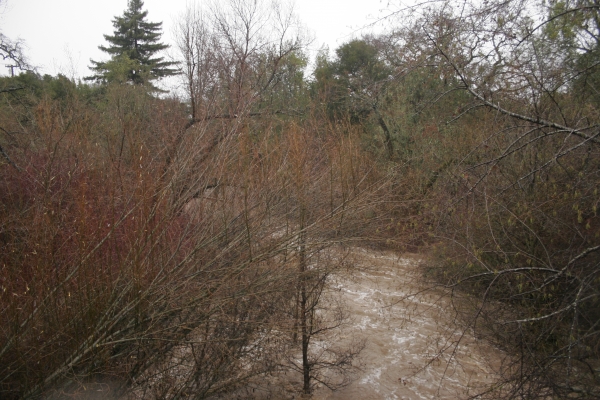


The Palo Alto City Council agreed on Monday night to explore a new law that would prohibit construction within 150 feet of streams and rivers.
The policy, which specifically targets the riparian corridors in the rural part of the city west of Foothill Expressway, came out of a set of recommendations from the Citizen Advisory Committee, a group that is helping the City Council revise the city's Comprehensive Plan.
On Monday night, the council approved with two unanimous votes the Safety and Natural Environment chapters (known as elements) of the plan, a broad document that will serve as the city's guide on land-use issues until 2030.
Many of the programs and policies in the new Natural Environment element are similar to those in the existing plan, with a strong emphasis on protecting open space; improving the urban forest; limiting noise; and ensuring clean air and water. One broad change between the existing document, which was adopted in 1998, and the new one is the inclusion of "climate change and climate adaptation" as a goal in the new version.
In a nod to more local concerns, the Natural Environment chapter also includes new programs relating to reducing airplane noise, enforcing of the leaf-blower ban and working to evaluate California's proposed high-speed-rail system. But the program that attracted the most attention Monday night was the one dealing with riparian corridors.
The Citizen Advisory Committee, which helped write much of the element, split between those members who believed that the limit should be expanded from 50 to 150 feet and those who wanted to further evaluate the issue before settling on a specific number.
Don MacDougall, a member of the citizen committee's Sustainability Subcommittee, is in the former camp. He called a 150-foot setback the "absolute minimum" and urged the council to adopt the program.
Shani Kleinhaus, also a member of the citizen committee, agreed and noted that other cities in the county, including San Jose and Mountain View, have recently moved to increase setbacks in sensitive habitats. San Jose adopted a 100-foot setback near its riparian areas while Mountain View created a "habitat overlay zone" in the North Bayshore area, prohibiting development within 200 feet of the riparian corridor. Santa Clara County has adopted a setback of 150 feet.
"Every time we plan and build too close to creeks, there are externalities that come to haunt us," Kleinhaus said. "We already see issues with flooding and with having to reinforce and concretize creeks not only in Palo Alto but everywhere."
The policy proposal quickly won over the council, with Vice Mayor Liz Kniss and Councilwoman Karen Holman quickly endorsing it. The only debate was whether the council should simply add a policy for the 150-feet setbacks or whether it should direct staff to explore it. The council ultimately chose 6-3, with Holman, Eric Filseth and Lydia Kou dissenting, to go with the more cautious language.
This quibble notwithstanding, all nine council members agreed that the updated Comprehensive Plan should include stronger protections for local creeks and streams.
"We have no idea what will happen next year -- a drought or a flood yet again," Kniss said. "Because this is a very uncertain environment, I'm going to suggest that 150 feet would be a desired stream-setback metric."
Holman concurred and said adopting the new setback requirements would place Palo Alto among the leaders in the realm of habitat protection. While Mayor Greg Scharff and the council majority were hesitant about adopting a specific number without further analysis and more public input, Holman had no such hesitations.
"It's what other cities in the county are doing and it's what the county is doing," Holman said. "I think it's quite appropriate."
The new program directs staff to explore expanding the setback along local rivers and streams to prohibit siting of buildings, impervious surfaces, outdoor activity areas and ornamental landscaped areas within 150 feet of the creek bank.
The new Comprehensive Plan program will not, in itself, establish the setback requirement along riparian corridors. It does, however, pave the way for the council to create an ordinance that would achieve the restriction. Planning Director Hillary Gitelman told the council that adopting such laws can be a complex endeavor.
"You're telling property owners that there is a section of their property that they may not be able to improve as they may wish to," Gitelman said.
The council also unanimously approved the Safety Element, which is built around the goals of risk prevention; protection from natural hazards and disasters; and human-caused threats. Council members were also scheduled to review the Business Element but agreed to delay that discussion until May 22.
Comments
Palo Alto Hills
on May 16, 2017 at 8:48 am
on May 16, 2017 at 8:48 am
"This quibble notwithstanding, all nine council members agreed that the updated Comprehensive Plan should include stronger protections for local creeks and streams."
If the nine council member were really looking to strongly protect local creeks and streams, then they would have voted for the protection last night rather than "explore".
Liz Kniss made the motion to protect the creeks, then pulled back when Greg Scharff reminded her there are creeks that go through Stanford University lands, in particular, Stanford Research Park. Liz Kniss pulled back from going with the stronger language and opted to go with "explore".
Developer monies.
Barron Park
on May 16, 2017 at 2:42 pm
on May 16, 2017 at 2:42 pm
This is good news. The next step is to remove all of the concrete from all of the creeks that flow down into the bay. That concrete is a significant barrier to the movement of wildlife between the baylands and the mountains and in many areas it creates wildlife islands and pinch-points which in turn causes inbreeding and that in turn causes the demise of the wildlife in the region.
Evergreen Park
on May 16, 2017 at 3:45 pm
on May 16, 2017 at 3:45 pm
I think the headline "Palo Alto looks to ban construction near creeks" is somewhat misleading.
After consideration of recommendations from the CAC the City Council decided to explore looking into an expanded
setback for new construction near creeks west of Foothill, that is consistent with county, regional and other municipal standards, of 150 feet.
"Banning construction near creeks" is, of course , a much much broader restriction, and nothing close to something that that was approved last night.
Adobe-Meadow
on May 16, 2017 at 4:05 pm
on May 16, 2017 at 4:05 pm
I watched most of that part of last night's meeting. It went on too long. Study...explore...study...explore. Council could have easily gone with the first motion by Liz Kniss, for 150 feet. Then it got bogged down by amendments and amendments to amendments. Now more time will be taken up by a very busy, too busy, PT&C and staff. And whatever is settled on for inclusion in the Comp Plan could be overruled by future ordinances, just like what happened the last time around. CC, get back to working on the really hard issues and questions confronting you. Remember them?...affordable housing, infrastructure, traffic, et al. So, I guess this latest decision will delay the final draft and approval of the updated Comp Plan, until the right setback number gets plugged in? Sad waste of time!
Downtown North
on May 16, 2017 at 4:39 pm
on May 16, 2017 at 4:39 pm
Building so close to the creek should NEVER have been allowed in the first place.
After the floods of the 1970s, when I was a small child, residents knew THEN that it was a horrible mistake!
another community
on May 16, 2017 at 6:12 pm
on May 16, 2017 at 6:12 pm
About time! If Stanford is in Palo Alto, it should abide by Palo Alto's rules. Why back off stronger language because of Stanford lands?
Charleston Meadows
on May 17, 2017 at 4:41 am
on May 17, 2017 at 4:41 am
The major creek that divides Santa Clara and San Mateo County starts on Stanford Land at the Dam at the top. The Dam is over 100 years old but SU refuses to take it down. We have had numerous discussions about the removal or replacement of the dam but no resolution. They have to be included in the discussion and resolution since they are the at the head of the creek.
And they have to respond with a more responsible approach since we are not in the drought phase and are now in the heavy weather phase.
Palo Verde
on May 17, 2017 at 8:43 am
on May 17, 2017 at 8:43 am
See Web Link for free links to online watershed maps.
Portola Valley
on May 17, 2017 at 8:47 pm
on May 17, 2017 at 8:47 pm
I commend the Council for efforts to set even slightly greater protection for the buffer zones to town waterways, and thus the creeks and rivers themselves, as well as the Bay. These enhance the experience of all residents of PA.
There is no question that an even slightly enhanced buffer zone is long overdue. The "quibble" might best be decided by going witht the Santa Clara County decision of 150 feet. Native vegetation in that zone would provide bank stabilization as well as habitat for birds and other native wildlife.
It's not often that Massachusetts is 50 years ahead of CA on sound, evidence based environmental policy.
In the 1960s Massachusetts passed The Wetlands Protection Act in order to protect for the public these valuable riparian zones. Please see: Mass.gov
Energy and Environmental Affairs
Protecting Wetlands in Massachusetts
(or just Google "Massachusetts Wetlands Protection Act")
What the PA Council is proposing is far less extensive than the MA state protections. and is a belated very small effort going forward in understanding the importance of the watercourses to the entire Palo Alto community and all of the natural and wildlife resources and erosion/flood control values that might be promoted by this even slightly enhanced zone.