


An effort by Palo Alto, Menlo Park and East Palo Alto to boost flood protection around San Francisquito Creek received an unexpected nudge from the federal government last month, when the Army Corps of Engineers received $646,500 to evaluate upstream work, including replacement of the Pope-Chaucer Bridge.
For the San Francisquito Creek Joint Powers Authority, the agency coordinating the flood-control effort, the allocation is a welcome departure from the prior two years, when the Army Corps received no federal money for the long-awaited study. The allocation, which the Army Corps announced on June 12, actually exceeds the $500,000 that the Santa Clara Valley Water District requested.
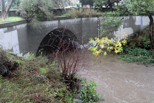
The funding will allow the Army Corps to complete its feasibility study for the project, which includes replacing the narrow and flood-prone bridge between Menlo Park and Palo Alto and widening the channel between the bridge and University Avenue. The study would set the stage for design work and possibly construction, which would be boosted by federal funds.
The study is one of two that is looking at replacing the Pope-Chaucer Bridge, which famously overflowed in the February 1998 flood, causing widespread damage to homes in the three Peninsula cities. The creek Joint Powers Authority, an agency that includes the three cities as well as water district officials from Santa Clara and San Mateo Counties, is now in the midst of conducting its own study of upstream improvements. That study, however, focuses on a somewhat broader geographical area (between Pope-Chaucer and U.S. Highway 101) than the Army Corps study, said Len Materman, the creek authority's executive director.
Both the Army Corps feasibility study and the creek authority's Environmental Impact Report, which is set to be completed by the end of this year, look at replacing Pope-Chaucer and widening the channel. The Army Corps study, however, could make the roughly $9-million project in its study eligible for federal funding.
Materman told the Weekly that while the allocation is a welcome development after two years without any federal funding, the agency is not banking on federal dollars to ensure safety. That's why it is pursuing its own study and lining up its own funding sources.
"This is good news because it keeps the federal government in the game, but none of us locally are banking on that resulting in construction dollars," Materman said. "If it comes through, great."
For the creek authority, the planned improvements at and around Pope-Chaucer would follow on the heels of another major flood-control project that the agency is pursuing in the particularly vulnerable downstream area, just east of U.S. Highway 101. The downstream project, which includes reconstructed levees in East Palo Alto and Palo Alto (on a property that was once part of the city's golf course), new flood walls and removal of sediment from the channel, kicked off in 2016 after nearly two decades of stop-and-start planning, is set to be completed at the end of this year.
Materman said the creek authority has reason to believe that the process of getting permits for the upstream effort will be less arduous than it was the the downstream segment. The authority has already spent a considerable amount of time working with all the state and federal regulators on the prior flood-control project, which should make work smoother this time around. It also helps that the upstream area only has one endangered species (the steelhead trout), while the downstream one has three (steelhead trout and the endangered California clapper rail and the salt marsh harvest mouse).
The creek authority's preferred alternative for the upstream work between Pope-Chaucer and U.S. Highway 101 is expected to cost about $25 million, Materman said. So far, it has about $10 million in funding, thanks to a parcel tax approved by Santa Clara County voters in November 2012. The authority is now evaluating other ways to pay for construction, in case federal money doesn't come in.
"At the same time that we're working with the Army Corps to get their study done, we're also completing our EIR and looking at other sources of funding through outside grants and exploring ideas about how to raise money locally," Materman said.
The biggest challenge, he said, probably won't be getting the money but designing a project that "everyone supports, including the regulatory agencies." The creek authority hopes to finish its Environmental Impact Report in the next six months, get the needed work permits next year and then construct the project in 2020 and 2021.
The ultimate goal of the various flood-protection projects is to protect the three cities around the creek from a "100-year flood," which has a 1 percent chance of happening in any given year. Once that kind of protection is implemented, residents around the creek will no longer be mandated to purchase flood insurance.
The planned upstream project contemplated in the Environmental Impact Report won't go that far, Materman said. It will, offer "70-year protection" Materman said -- enough to shield the neighborhoods from the biggest flow the area has seen since it began measuring floods, though not enough to get households out of the flood-insurance program.
"Generally speaking, if we replace Pope-Chaucer and do the channel widening, the objective would be so that a repeat of the 1998 event doesn't flood anyone's home," Materman said. "If we can protect against that, I think it's meaningful."
The creek authority, he noted, is also working with Stanford University to explore the creation of a detention basin on Stanford property, either at Searsville Dam or at Webb Ranch.
"As part of the bigger solution, we want to go beyond the 70-year and get to 100, and get people out of the flood-insurance program."
Related content:
A flood next time?: A look at changes to end San Francisquito Creek's threat
Comments