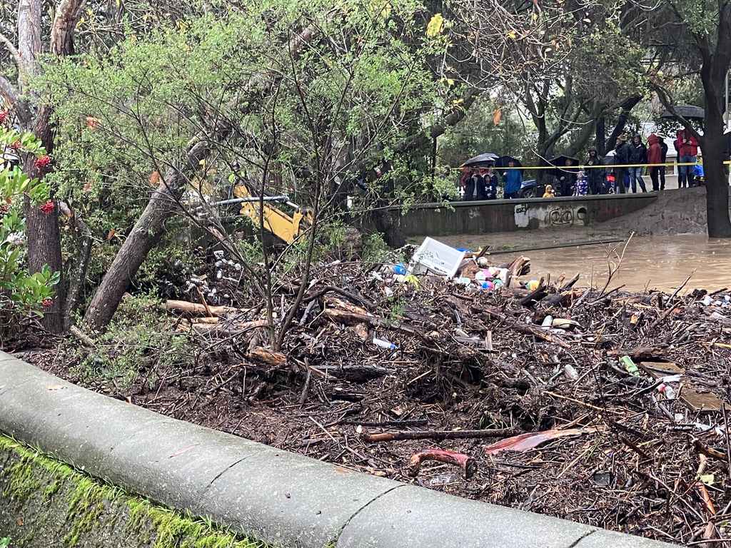

An ambitious plan to reduce flood risks for Palo Alto and Menlo Park residents near the Pope-Chaucer bridge is now on the verge of faltering after the agency overseeing the project concluded that the long-awaited replacement would actually endanger downstream areas.
The analysis, which was released this week and which the San Francisquito Creek Joint Power Authority board of directors discussed at a special meeting Thursday, represents a stinging setback for the agency's plans in what's known as "Reach 2" — the area between Newell Road and Pope Chaucer bridges. The creek authority had been planning to replace the Newell Road bridge and to widen the channel before commencing work on the Pope-Chaucer.
While the first two components of this plan remain on track, the new analysis from creek authority engineer Jack Xu is forcing the agency to reconsider its plans for the Pope-Chaucer bridge. The analysis concluded that unless the three cities along the creek — Palo Alto, East Palo Alto and Menlo Park — install flood walls along much of the creek, the risk to downstream areas such as University, Woodland and Euclid avenues would become significantly greater as a result of the Pope-Chaucer replacement. That's because in its current configuration, the flood-prone bridge functions as a dam during storms, restricting flow to downstream areas.
"If Pope-Chaucer is in place, the communities on University and downstream will never see a flow higher than a certain amount," Xu said. "When you remove that bridge, suddenly all the water gushes down and you'd have to protect those people from all the water that would come down if you remove the Pope-Chaucer."
The agency began to revisit its assumptions about the hydrology of the volatile creek after the New Year's Eve storm, which caused flooding near Pope-Chaucer and in other sections around the creek. Xu said the flooding during that event did not match what the creek authority's modeling had predicted. The existing model, which was based on a 2009 analysis by a consultant, relied on data from four prior storms, all of which were less severe than the one that occurred during New Year's Eve.
Xu's report notes that the prior model had underestimated the "roughness" of the creek — a measure of vegetation, debris and other blockages that interfere with the creek's flow. The prior analysis had also overestimated the capacity of the channel by as much as 2 feet in some area, the report states.
To protect downstream communities from increasing flood risk resulting from the Pope-Chaucer bridge's removal, the creek authority would have to build flood walls 1,000 feet in length and 1 or 2 feet in height, depending on the level of protection that the agency would be seeking to achieve.
Given the findings, the creek authority is preparing to reopen some of the other flood-control alternatives that it had evaluated in the Environmental Impact Review for the "Reach 2" section of its plan. This will include, among other things, further evaluation of options for detention basins upstream.
Tess Byler, project engineer at the creek authority, said the recent analysis made it clear that the hydraulics at the creek have changed.
"That's a shock to everybody," Byler said.
Both she and Xu suggested that moving ahead with the Pope-Chaucer removal would be politically difficult, given historical opposition by property owners along the creek to having floodwalls installed along the creek.
"It would be very difficult to get a project where you can remove Pope-Chaucer," Xu said. "It would take a lot of floodwalls. The history of the project shows there's no appetite for that."
The news also came as a shock to the residents in Crescent Park in Palo Alto and the Willows in Menlo Park, many of whom have been lobbying for the Pope-Chaucer bridge to be replaced since the major flood of 1998. Tom Rindfleisch, a Crescent Park resident who has been tracking the ebbs and flows of the flood-control project for years, said Thursday that many people in his neighborhood have trouble sleeping during rainy seasons because of flood risks. He challenged the creek authority not to abandon the project.
"There are going to be people who are really put out by this because of the continuing fear over the winter rain season on how they can protect their homes and their lives and their properties," Rindfleisch said. "I believe the solution has to be get rid of Pope-Chaucer bridge and fix the downstream creek so it can hold the capacity for what will undoubtedly flow downstream."
Menlo Park City Council member Drew Combs, who chairs the creek authority's board of directors, shared his disappointment. Months ago, he had been telling residents in flood-prone areas near the creek that the long-delayed project would be finally coming, Combs said. He had also believed that the construction on Reach 2 would start before his term on the creek authority expires, a prospect that now seems less likely.
"This is a general frustration with the situation, but facts are facts. The science is the science," Combs said.
Palo Alto Vice Mayor Greer Stone, who also serves on the board, urged the creek authority's staff to consider possible mitigations that could improve flood control in case Pope-Chaucer is not replaced. He called the new analysis "concerning."
"Some of the residents impacted by flooding there finally saw light at the end of the tunnel for that portion of the creek," he said.
Given the latest findings, the creek authority plans to take a fresh look at other design alternatives, a process that will likely require additional analysis and will almost certainly delay the project even further. Board member Rebecca Eisenberg, who represents the Santa Clara Valley Water District on the creek authority's board, urged staff to explore emerging technologies and other mitigation strategies to address flood control.
"Because the current situation is not tenable… It's just not," Eisenberg said. "The answer can't be, 'So sad. Too bad. Live with it.' That's not going to be OK."
A new analysis by the San Francisquito Creek Joint Powers Authority has found that replacement of the Pope-Chaucer would send more water downstream, putting that area at risk of flooding.
Comments
Registered user
Crescent Park
on Jun 8, 2023 at 8:29 pm
Registered user
on Jun 8, 2023 at 8:29 pm
Sorry, but it’s time to fix the Chaucer bridge and say “tough luck” to the property owners who are downstream of the bridge and who might be vulnerable to increased flooding if the bridge is fixed. Look at it this way: if a big tree fell into the creek, and blocked the flow, that would “protect” everyone downstream, but flood the properties upstream. Would anyone seriously argue that therefore, the tree should not be promptly removed to restore the prior natural conditions? It’s the same with the bridge, which was improperly designed years ago and has created an unnatural blockage of the creek. The city was and is strictly liable for this improper design, under at least the principle of "inverse condemnation." As stated in Albers v. City of Los Angeles, 62 Cal. 2d 250, 263-264 (1965), "any actual physical injury to real property caused by [a public] improvement as deliberately designed and constructed is compensable ... whether foreseeable or not." There is no reason to believe that further flood events will not cause further damage as the direct result of the artificial constriction caused by the bridge, thus exposing the city to further liability. In contrast to the strict liability that the city is exposed to by leaving the bridge as is, the city would be shielded from any claims for damages "caused" by removal of the bridge. In Locklin v. City of Lafayette, 7 Cal. 4th 360 (1994), the California Supreme Court held that if a public agency makes flood control improvements to flow of a natural watercourse, and if those improvements are reasonable, the owners of downstream property "must continue to accept the burden of damage caused by the stream water." It is this point that pertains to the current arguments, to the effect that removal of the bridge will transfer flooding downstream. There can be no genuine dispute that it is reasonable to improve the Chaucer Ave. bridge to correct the mistaken design of 1948.
Registered user
Old Palo Alto
on Jun 8, 2023 at 11:03 pm
Registered user
on Jun 8, 2023 at 11:03 pm
Incredible! The flood of 1998 was when the city and the joint powers needed civil engineers the most. Yet on the doom of the Internet boom, software engineers exploded on the Peninsula and predominately grew a Silicon Chipped Valley. And so here we are at a riveted steel marker apex. A actual bridge for travel is ubiquitously serving as a damn! Are we so far removed from actual infrastructure breakdown and glued to Auto-Cad scenarios justifications to not replace a bridge because it’s structure acts as a flood plug downstream? It’s time for OES assessment. Apparently if it can’t be 3D printed or designed & installed by sexy robotics we are relying on the mid-20th bridge infrastructure as a twofer . Bridge&Dam. Who said it’s like the bridge over the River Kai ? If it looks like a bridge it’s not. It’s a dam. Might as well put up a sign “Welcome to Hollywood” .
Registered user
Community Center
on Jun 9, 2023 at 10:39 am
Registered user
on Jun 9, 2023 at 10:39 am
Why not just clear out some of the in channel obstructions (e.g. trees: living and dead), rocks and dig a little deeper in areas that might overtop?
Registered user
East Palo Alto
on Jun 9, 2023 at 11:30 am
Registered user
on Jun 9, 2023 at 11:30 am
IIRC Norman Beamer no longer lives in the area but his lack of concern for downstreamers remains intact.
Registered user
Old Palo Alto
on Jun 9, 2023 at 11:38 am
Registered user
on Jun 9, 2023 at 11:38 am
Bridges are not designed to be dams. What happens if it gives way during a flood?
Registered user
Adobe-Meadow
on Jun 9, 2023 at 11:45 am
Registered user
on Jun 9, 2023 at 11:45 am
Palo Alto should consider using the golf course to reduce the risks of flooding of East Palo Alto homes. This was an option that was rejected when the golf course surrendered 7 acres to the Flood Management project East of 101. Maybe time to reconsider, and provide flood plain capacity at the golf course during extreme rainfall events.
Registered user
Duveneck/St. Francis
on Jun 9, 2023 at 12:12 pm
Registered user
on Jun 9, 2023 at 12:12 pm
A massive flood channel was installed years ago to cover East Palo Alto houses out by the bay.
It’s tume NOW to protect Palo Alto and Menlo Park.
Registered user
Crescent Park
on Jun 9, 2023 at 1:28 pm
Registered user
on Jun 9, 2023 at 1:28 pm
On June 10, 2014 the SCVWD Directors held a public hearing on a modification to the SFC flood protection project being developed jointly with the SFCJPA. The driving issue was funding — not enough money to implement a Preferred Project (PP), i.e., upgrades to the creek to contain at least a 100-year flow — 9,200 cfs from Middlefield bridge to the bay. The dilemma was should we wait an indeterminate time for federal, state, and local funding to be available to start the PP, or should we undertake a lesser Modified Project (MP) now, using available state and local funding? After much debate, SCVWD voted unanimously (Director LeZotte absent) to adopt the MP. SFCJPA Directors agreed.
The MP included (a) the PP upgrades in Reach 1 from the Hwy 101 bridge to the bay (done in 2019) and (b) in Reach 2 removing Newell and P-C bridge intrusions into the natural conformation and flow capacity of the creek, widening of 4-5 pinch points, and improving bank/floodwalls to contain around 7,200 cfs.
It is no surprise that the flow downstream of the P-C bridge would increase with its removal. Why Mr. Xu now cites this as the reason for abandoning the P-C bridge upgrade is hard to understand. Reach 2 widening and bank improvement work is focused mainly on minimizing the risk of flooding for everyone as much as possible. The MP unavoidably entails some flood risk from very high flows for all residents near the creek.
I strongly believe the Reach 2 work should proceed as planned and Mr. Xu's studies should update the model to account for current Reach 2 plans and any recently identified bank/channel problems. Then explore plans for better bank and channel treatments to maximize protection for properties bordering the creek and estimate the flow accommodated by the creek.
25 years after the 1998 flood, we can’t have more years of anguish over how to restore the natural capacity of the creek and protect residents from the ill-considered construction of the P-C bridge many years ago.
Registered user
Menlo Park
on Jun 9, 2023 at 3:35 pm
Registered user
on Jun 9, 2023 at 3:35 pm
Valley Water is showing that if Pope-Chaucer was replaced, their updated modeling (based on the actual water levels observed and documented during the New Year’s Eve flood) shows that there would need to be 4 miles of 3-foot to 6-foot floodwalls from the Newell Street Bridge up to almost Pope Chaucer. 3 to 4 feet plus up to 2 feet additional on outside curves.
=======================================
Jack Xu, a Professional Engineer & Certified Flood Manager in the Valley Water Hydrology, Hydraulics and Geomorphology Unit, presented this conclusion in his June 8, 2023 presentation to the SFCJPA:
"Transfer of Flood Risk
Pope Chaucer cannot be replaced without a significant increase to the Reach 2 Project
• Floodwalls 3' - 4' for 2 miles on each side, from Newell Road up to almost Pope Chaucer"
=======================================
In Xu's June 5, 2023 technical memorandum, he added:
CREEK SUPERELEVATION
Creek superelevation is a phenomenon that occurs when water flows around a bend in a creek. The water on the outside of the bend moves faster than the water on the inside of the bend, which creates a higher water level on the outside. There are areas on the outside of bends that are shown to have flooded on NYE, but the revised models do not. Superelevation is not considered in the HEC-RAS model and must be accounted for separately. Using a simple methodology from the US Army Corps, an estimate for recommended additional freeboard due to superelevation at various locations ranges from 0.75’ to just under 2.0’
Registered user
Crescent Park
on Jun 9, 2023 at 4:05 pm
Registered user
on Jun 9, 2023 at 4:05 pm
how is this a surprise or shock to anyone associated with this effort? Hasn't this been identified previously in EVERY study on this issue? Each bridge on the creek has a designed maximum flow. Enabling more water to flow under a bridge upstream means the downstream bridges are the next in the line. This is a joke.
Registered user
Menlo Park
on Jun 9, 2023 at 4:34 pm
Registered user
on Jun 9, 2023 at 4:34 pm
Before the JPA throws the current plans in the trash, what I would ask is that they hire an unbiased hydrologic modeler to review the Valley Water report. Too much is riding on this to accept unquestioningly the conclusions of an agency that historically is more comfortable paving over creeks than maintaining them in their natural state. For example, is the fact (if true) that more debris was observed at the Pope-Chaucer bridge in 2023 versus 2012 due to the effect of four years of extreme drought? Weakened trees falling in the creek this year are not surprising, but using those conditions to represent all future conditions is not appropriate.
Registered user
Another Palo Alto neighborhood
on Jun 9, 2023 at 4:46 pm
Registered user
on Jun 9, 2023 at 4:46 pm
101 was closed overnight and the lanes all moved, and lots of work was done for months for work on this creek and then there was single lane on Bayshore near the Post Office for months to prevent flooding along with huge green levees in East Palo Alto. Why is this still a problem after all that work and all that money spent? I was under the impression that this work was so that the Chaucer bridge could be replaced. Was that misinformation and why were we told otherwise?
Registered user
Adobe-Meadow
on Jun 9, 2023 at 6:53 pm
Registered user
on Jun 9, 2023 at 6:53 pm
Will the analysis have to change again when Searsville Dam is modified to allow water flow through the dam and into the Channel? The flows MUST be modified when water flows through rather than over the dam?
The planners said they have to start near the Bay, and move up the channel with the flood management "improvements". So was that approach wrong for this particular stream?
Registered user
Crescent Park
on Jun 9, 2023 at 8:30 pm
Registered user
on Jun 9, 2023 at 8:30 pm
This is supremely disappointing news. Were all the previous engineering studies over the past 25 years erroneous? At a minimum the conclusions Jack Xu reached should be corroborated by another engineering firm before the PC bridge project is modified or cancelled; 25 years of work can’t be halted by a single analysis. Xu seemingly alludes to a benefit of keeping the current PC bridge in place because it acts as a dam that limits downstream water flows. I’d add that the bridge accomplishes this by flooding Crescent Park. We as a community need to take coordinated action to motivate the SFCJPA to reverse this decision or commit to another plan that can be accomplished in the same time frame. We can’t wait any longer, we can’t have more nights of sandbagging and worry during heavy rain.
Registered user
Old Palo Alto
on Jun 10, 2023 at 8:39 am
Registered user
on Jun 10, 2023 at 8:39 am
As a very long time local remembering the mid ‘50’s floods, I have a simple suggestion. How about higher flood walls perhaps between Middlefield and Chaucer along with regular debris removals in that area as well?
Cheaper, easier, sooner, no?
Registered user
Crescent Park
on Jun 10, 2023 at 3:56 pm
Registered user
on Jun 10, 2023 at 3:56 pm
Re Pat Landman suggestion. Pat, raising the banks at Hale and Seneca, where the overflows occurred from the "lake" that built up behind the Pope-Chaucer bridge on Dec 31, would increase the maximum flow capacity only by ~200 cfs (to ~5,700 cfs ) before it would overflow the wall at Pope-Chaucer bridge itself (based on the latest rating curve for P-C). We're trying to accommodate somewhere ~7,200 cfs to reduce the flood risk seen in the 1998 flow of record, which is why we need to upgrade the P-C bridge.
Registered user
Crescent Park
on Jun 10, 2023 at 4:14 pm
Registered user
on Jun 10, 2023 at 4:14 pm
Dear downstream owners: you have NO RIGHT to complain about fixing the bridge. Restoring the creek to its natural state by fixing the bridge is necessary and appropriate no matter what the consequences of restoring the status quo ante.
Registered user
Duveneck/St. Francis
on Jun 10, 2023 at 10:55 pm
Registered user
on Jun 10, 2023 at 10:55 pm
I looked at the report describing the modeling effort - it was quite well done. In particular, the increases in Mannings n (the friction coefficient) used in the calibration effort seem very warranted given what the creek interior looks like. I am not sure as to what was used by Noble and the Corps in their modeling, but when our neighborhood group did our own modeling back in 2003, we increased n uniformly by 20% over the values that SCVWD was using at the time so as to best match the very limited observations available in early 2003. The new modeling does suggest that removing as much as possible of the vegetation in the channel (not on the banks), especially non-native plants and trees, would be helpful. I liked the fact that the report brought up the issue that bends in the creek can cause superelevation of the water surface on the outside of the bend - these need to be accounted for in design of any flood control measures. The bottom line is that I would be hard pressed to imagine anyone doing a model of similar or better fidelity that showed anything other than what was reported to the JPA this past week.
However, one aspect of the new modelling report that should be corrected is the map of where overflows occurred on 12/31 (figure 2) – the figure omits the overflow that occurred by the pump station at Hale and Palo Alto Ave. This omission is important because Hale St. is upstream of the bridge - how much of the water that came through on the Palo Alto side between there and Palm St. would be good to know, but it does appear from video and photos that the upstream overflow was significant. It would be good if someone could construct a map of where water flowed, e.g., along Center, Pitman etc., and if possible, flow depths.
Registered user
College Terrace
on Jun 11, 2023 at 7:14 am
Registered user
on Jun 11, 2023 at 7:14 am
Between this decades old issue and the grade separation issue, I cannot help but think of Atlas Shrugged.
Registered user
Crescent Park
on Jun 16, 2023 at 8:49 am
Registered user
on Jun 16, 2023 at 8:49 am
We have agreed to fix the creek from downstream to upstream to ensure that risk of flooding will not be transferred downstream. The modeling of the creek also needs to reflect planned work from downstream to upstream. The model presented on June 8 does not do that. The model needs to be redone and updated to reflect that improvements upstream will be done only after improvements downstream are completed, especially the removal of the huge cement wall inside the creek between Euclid and Manhattan on the East Palo Alto side just upstream of University Ave.
The goal of Reach 2 project has been and needs to be to accommodate flows of 7,200 to 7,500 cfs. That is the flow that can pass under Middlefield Bridge, and that is also the flood of record in 1998. Reach 2 project needs to include the replacement of Pope Chaucer Bridge that blocks the creek and overflows at 5,400 cfs. Those of us in the shadow of Pope Chaucer Bridge have been waiting patiently for 25 years; any further delay is unacceptable.
Prominently, there is a cement wall on the East Palo Alto side between Euclid and Manhattan that blocks the creek. It is immediately downstream from Oak Court and Euclid, where the creek overflowed on Dec 31. This is a huge structure INSIDE the creek! The wall is wide, it's the entire height of the creek bank, and it is a block long! There is even a staircase that leads into the creek bed! It is at a narrow point where the creek turns, immediately downstream from the overflow point. It takes up a huge amount of volume in the creek! There is a chunk of cement actually intruding into the creek and blocking water flow. I am enclosing a few photos below. I urge you to go and take a look at that cement monstrosity inside the creek -- you can see it from Woodland between Euclid and Manhattan.
This wall would be removed as part of the channel widening; and Jack Xu/SCCWD absolutely needs to redo the modeling with this wall removed.